Layer
Joni Baboci is an architect, planner and all-around urban enthusiast. He is the founder of Layer (https://getlayer.xyz), a spatial orchestration platform with global data coverage which empowers teams to govern through tactics and patterns while leveraging machine learning and artificial intelligence. He has previously served as the General Director of Planning and Urban Development for the City of Tirana and the director of Atelier Albania, a structure of the Albanian government dealing with national and regional strategic planning; Joni has executed planning, design & development projects at different scales at the national, regional and local levels. He consults on urbanism and planning for various cultural and multilateral institutions. Joni holds a Bachelor of Arts in Architecture from the University of Toronto and a Master of Science degree in Cities from the London School of Economics. You can find more about him on his website (https://joni.baboci.net) & newsletter (https://thinkthinkthink.substack.com).
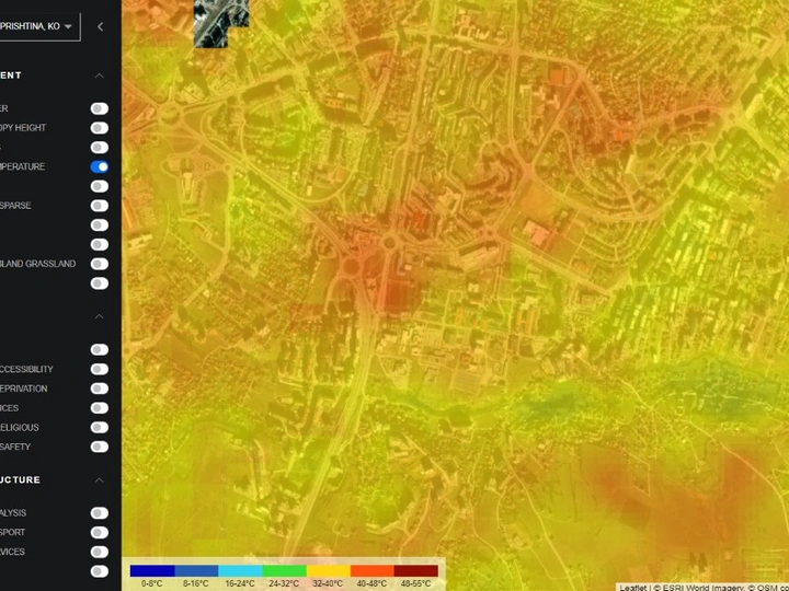
Layer is a special orchestration platform with global data coverage, empowering teams to govern through tactics and patterns, while leveraging machine learning and artificial intelligence. It was born out of my experience as general director of planning and urban development for Tirana, the capital of Albania - where a lack of general data, their granularity, and the lack of georeferencing made it difficult to employ data in urban planning. Layer enables cities around the world to access hundreds of datapoints - it serves as a collection of information which attempts to tackle environmental and social issues by putting spatial data in the hands of decision makers: whether it’s land surface temperature across a city or accessibility isochrones for different neighborhoods layer is a simple interface to improve data usage in architecture, urban planning and development.
Layer maintains a growing collection of more than 120 global spatial datasets. We continuously ingest updated spatial temporal information from leading space agencies as well as private sector imagery providers, and make them usable and useful to citizens and decision makers.
We would want to work with the city of Prishtina in giving them access and improving our platform by learning through this common engagement. We can help in assessing the impacts of climate change, historical and temporal land surface temperature records from the 1970s onwards as well as measuring rainfall, as well as other climate related data. We can evaluate access to various public and private amenities, including schools, pharmacies, police stations, and other institutions. We can then generate walking, driving and public transportation mobility and accessibility isochrones from other amenities can help infrastructure by conducting complex network analytics on critical segments of the infrastructure grid, and assess urban mobility performance.