Site Drawing, from GPS tracking to architecture
Spatial designer currently graduating from Master course in Geo-design at DAE
and graduated from an undergraduate in "living spaces, atmosphere and
environment" at school Duperré (Paris). Working in between research based design, furniture and production and spatial interventions. I had the chance to spend two summer sessions in Domaine de Boisbuchet, a residency created by the first director of Vitra Museum. My work is rarely individual, it always seeks collaborations and social inputs from ecovillage residents to kids in parisian suburbs as participants for my workshops. Curated and lead the set design of an independant exhibition during Dutch Design Week 2023 and had a short stay at the Central Saint Martin (London) for a product design course.
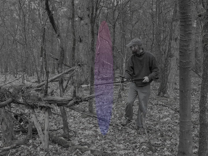
“Site drawing, from GPS tracking to architecture” or “for a located digital practice” is a technological methodology for spatial design developed within the GEO-design Master by Anton Ripon. The practice is based on a GPS receiver fixed to a telescopic stick tracking the movement of the participant within a site. Like a pen on a paper, the movements are recorded in 3 dimensions to be able to design the spatial project with centimeter accuracy. Digital design is based solely on a simulation created by satellite views, cadastral plans or other data extraction. By performing the design in situ, the model is accurate and site specific, canceling the need for a simulation. The practice has been influenced by the ethics of ecovillages: a critical approach to tools, an ecological locality and an embodied human-scale design. Therefore, the tool has been tested back within ecovillages to conduct landscaping, interior design or shelter design with their residents. What is presented is both the performance of drawing and the digital documents produced from this moment in different contexts. The participant, the weather, the amount of satellites received, the site specificity and the aim of the drawing are all components manifested within the drawing.
The next step would be to expand this research with different communities, different rural contexts within Europe and with different professionals within the architectural field to implement the tool and the methodology to a wide spread open-source practice.