"Extreme Terres of Anthropocene"
Margherita Pasquali
is a. P.h.D. Architect graduated from the Polytechnic of Milan in Architecture with honors (2019), during her university career she won the scholarship "Tesi all’estero" at the PUC, Santiago de Chile. She gained her P.h.D. in “Architecture, Planning and Landscape” at University of Trento with the thesis “Extreme Terres of Anthropocene”. Among her Phd experiences she takes part in the PRIN B4R project; has been co-curator of the Accademia dei Lincei awarded research “Medways_Le vie del Mediterraneo”curated by Mosè Ricci. She was Phd visiting student at IAAC in Barcelona, focusing on mapping design tool for extreme territories. She also taught landscape and urban studies at University of Trento and University of Genova.
The knowledge and competence of tools acquired as Opendata, Qgis, Semiologiquè graphiquè and a basic knowledge of grasshopper, during my previous experiences (Digi Skills POLIMI, MSlab POLIMI) and during my Phd path (Exploration B4R, Gis Course, Environmental data analysis course), can be decidedly increase and developed to support the research program, thank to this possibility.
In particular, I think that dealing with a different academic reality can make me grow a lot and give me the tools to be a better support for the research team (B4R-PRIN2017).
Since 2015 she is collaborating with the architectural bureau Pasquali Giaume Architetti Associati.
In 2018 she founded Dispace Landscape Architecture an interdisciplinary design practice and research agency led by the architect and landscape urbanist Carlotta Olivari and PhD. architect Margherita Pasquali, based in Milan (IT). The studio operates at the intersection of architecture, landscape and urbanism, working through a diverse range of outcomes-from landscape architecture design, landscape urbanism, experimental research to data visualisation. Dispace’s ambition is to design new ecologies in the contemporary living space.
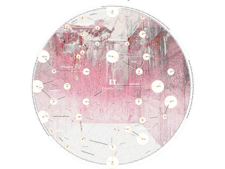
The PhD investigation, titled "Extreme Terres of Anthropocene: An Ecological Landscape Design Approach for Italian Innerland," delves into a new landscape category, advocating for its sustainable development via innovative evaluation and planning tools. Focused on Val di Sole in Trentino, the study seeks to: i) map Extreme Terres using GIS-assisted multi-criteria evaluation, pinpointing critical areas and intervention zones; ii) devise strategic scenarios via dynamic mapping to address landscape dynamics across various space-time scenarios; iii) establish a roadmap for replicating the methodology across Italy. Situated at the nexus of debates on extended urbanization and risk resilience, the research introduces the concept of Extreme Terres, challenging traditional cartography and GIS approaches with a dynamic design process. It merges insights from critical urban theory with geospatial tools to tackle the socio-ecological intricacies of inner Italian areas. The project offers applied geospatial methodologies for social and ecological issues by integrating critical theorists like Lefebvre, Moore, and Brenner with GIS-driven decision-making in landscape ecology. The forthcoming publication, structured into four parts with a preface by Nikos Katsikis, will contributing significantly to ongoing discussions on the hinterland question. The whole research is structured by the introduction part (Abstract; Structure of the thesis; Glossary), the methodology, the design process and Final Considerations (plus Index, Thematic bibliography).
Overall, this research criticizes the conventional idea of cartography and GIS and it combines theoretical insights from critical urban theory with a robust geospatial apparatus, addressing pragmatic questions in the crucial “inner areas” of the Italian context. Facing two growing debates in design: one around the spatialities of more-than-city, more-than-human territories of “extended urbanization” and one around risk and resilience.