Seascape Atlas: Mapping the Unheard
In-Depth-Space, founded by Di Fang, serves as an experimental platform fostering transdisciplinary collaboration in researching and discussing ecological challenges. With an academic background in architecture and urbanism, Di Fang is committed to exploring diverse topics and methodologies in her research pursuits. Her primary passion lies in investigating the intricate relationship between humans and water across varied social landscapes, encompassing rivers, seas, and other water bodies.
In her projects, Di collaborates with scientists and artists, utilizing design and artistic mediums as tools for research and platforms for conveying research findings. She firmly believes that creative methods can illuminate obscured narratives and offer fresh perspectives on entrenched societal paradigms.
Currently, Di is engaged in two ongoing projects that delve into the intricate relationship between humans and water across diverse cultural contexts. The first project, titled "Seascape Atlas," delves into a land reclamation initiative and its ecological consequences in the Netherlands. Supported by a starting grant from Creative Industries Fund NL, this project entails collaboration with a sound artist to explore innovative counter-mapping methodologies. The second project sheds light on the unique oceanic worldview of an endangered Indigenous maritime group in the Sulu Archipelago of Southeast Asia. By situating one project in the global north and the other in the global south, the research endeavors to elucidate the contrasting perceptions of the ocean within Western-centric and Indigenous worldviews.
In addition to her research projects, Di actively participates in academic activities such as workshops, presentations, and writing engagements. She has contributed to prestigious institutions in relevant fields, including IHE Delft Institute for Water Education, Port City Futures (LDE) & UNESCO Chair Water, Ports and Historic Cities, and TBA21 Academy.
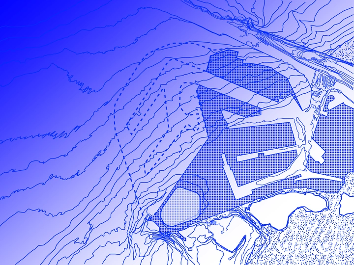
Situated at the nexus of land and sea, the expansion of the Port of Rotterdam encapsulates the ongoing tension between human development and the conservation of natural spaces, spanning both terrestrial land use planning and marine spatial planning. However, the infrastructural evolution linking land and sea is outpacing the integration of these connections into mapping, planning, and policy frameworks.
Cartography, as the predominant tool in spatial planning, is inherently designed to depict static terrestrial spaces, rendering it inadequate for representing the dynamic nature of the ocean—a fluid, deep body with ever-changing assemblages. Moreover, modern cartography's reliance on satellite technology and abstract representations has supplanted the tactile measurements and narrative richness derived from human exploration. This technological shift has diminished the sensory experience crucial for comprehending landscapes in their entirety.
The absence of a tool capable of mapping the ocean's fluidity and depth impedes what I term 'oceanic thinking'—the ability to engage with and think alongside the ocean. Furthermore, the loss of sensory connection in mapping inhibits the development of 'oceanic feeling'—empathy towards the ocean and its inhabitants. Without both, our capacity for sensitive and sustainable interaction with oceanic environments is severely limited, with profound implications for the planet as a whole.
The project employs counter-mapping to discover new ways of mapping. It aims to examine the ecological repercussions of a land reclamation project on the North Sea and amplify the narratives of more-than-human communities. By envisioning a multimedia atlas comprising speculative maps, soundscapes, and audiovisual elements, the project explores alternative cartographic representations that defy conventional norms and dominant power. Through these endeavors, it strives to cultivate a deeper connection to non-human communities and landscapes.